
Nouadhibou sits on a narrow peninsula along the Atlantic coast of Mauritania, close to the disputed territory of Western Sahara. Formerly named Port-Étienne, it is Mauritania’s second-largest city, but it often feels more like an industrial frontier than a conventional urban center.

Iron ore trains from the interior terminate here after crossing hundreds of kilometers of desert. Fishing boats crowd the harbor before dawn. The air carries salt, diesel, and iron dust. Offshore, rusting hulls still drift in shallow waters, remnants of what was once considered the largest ship graveyard in the world.

A ship graveyard is exactly what the name suggests: a place where vessels are abandoned, dismantled, or left to decay. Some emerge from catastrophe. Namibia’s Skeleton Coast is lined with wrecks destroyed by currents, fog, and reefs. Bangladesh’s Chittagong and India’s Alang became industrial dismantling zones where ships are systematically broken apart for scrap. Australia’s Rottnest ship graveyard was deliberately used as a dumping ground for obsolete vessels throughout the twentieth century. Nouadhibou was different. It was not created by storms or organized shipbreaking industries. It grew through accumulation, through decades of informal agreements, corruption, weak regulation, and economic convenience.

By the 1980s and 1990s, abandoning an aging ship in Nouadhibou had become cheaper than dismantling it legally elsewhere. Shipowners from Europe, Asia, and other parts of Africa reportedly paid small bribes to local officials, then left unwanted vessels in the bay. Over time, more than 300 wrecks collected along the coastline and in shallow water. Some sat upright with their bridges intact. Others split apart and partially submerged. Tankers, trawlers, tugboats, refrigeration ships, and cargo vessels accumulated without order. Satellite images from the early 2000s show entire clusters of wrecks jammed together like floating industrial ruins.

The geography of the bay helped make this possible. Dakhlet Nouadhibou is naturally sheltered from strong Atlantic currents and storms. The waters are relatively calm, making the harbor valuable for fishing and maritime trade, but also ideal for abandoned ships that might otherwise drift or sink elsewhere. Once a vessel entered the bay, it could remain there for decades.

Some of the ships carried histories that stretched far beyond Mauritania. The oldest known vessel associated with the graveyard is believed to be the French cruiser Chasseloup-Laubat, a late nineteenth-century warship that ended its life in Nouadhibou in 1926. Long before the graveyard expanded into a sprawling cemetery of rusting hulls, the cruiser had already established the bay as a maritime resting place.

Many later arrivals came from the global fishing industry. European and Soviet-era trawlers appeared in large numbers after they became economically unviable. Refrigeration ships that once transported fish across continents were stripped of equipment and left behind. Some vessels were partially dismantled by local salvagers who removed engines, copper wiring, anchors, navigational equipment, and steel plating. Others remained almost intact for years, creating surreal scenes where rusted freighters floated beside brightly painted wooden fishing boats.

Photographers who visited Nouadhibou during the graveyard’s peak often described the bay as a floating industrial archive. Hulls displayed faded company insignia from multiple countries. Names could still be read on certain ships long after ownership records had disappeared.

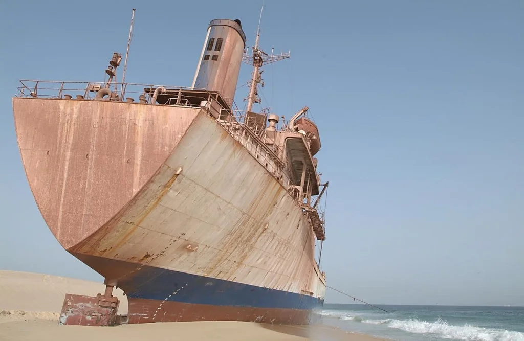
Among the wrecks that came to define Nouadhibou’s coastline, none became more recognizable than the United Malika, a 387-foot Moroccan refrigeration vessel that ran aground near Cap Blanc on August 4, 2003 while carrying a cargo of fish from Las Palmas. The ship’s seventeen-member crew was rescued by the Mauritanian Navy, and much of the cargo was recovered, but efforts to refloat the vessel failed. The United Malika was subsequently abandoned and absorbed into the expanding ship graveyard, where its massive rusting hull became one of the most photographed structures in the bay. Built in Japan in 1979 and modified several times over its operational life, the vessel embodied the long global journeys that many of Nouadhibou’s wrecks had taken before ending on the Mauritanian coast. For years, travelers, photographers, and salvage workers treated the ship as both landmark and symbol, an industrial carcass stranded between desert and ocean. Recent reports suggest that much of the vessel has since been dismantled by scrap dealers, and satellite imagery indicates that the United Malika may now have disappeared almost entirely from the shoreline.

United Malika

The contrast between the abandoned ships and Nouadhibou’s fishing economy became increasingly striking during the last decade. Satellite imagery shows a dramatic expansion of the artisanal fishing port, with thousands of narrow wooden pirogues packed closely together along the shoreline.

The 2015 satellite image of Nouadhibou captures a port still defined by separation and visible boundaries. The artisanal fishing harbor occupies a relatively compact section at the edge of the city, with long rows of wooden pirogues arranged in clusters that still leave strips of visible water between them. The ship graveyard remains part of the surrounding landscape, but the fishing economy appears contained and almost orderly from above. Open shoreline and undeveloped sandy areas surround the harbor, giving the impression of a city whose maritime infrastructure has not yet fully overtaken the coastline. The image is striking because it preserves a transitional moment: Nouadhibou still resembles the remote industrial outpost that travel writers and photographers had documented for years, suspended between abandonment and expansion.

GEOSAT Very High-Resolution satellite image, Nouadhibou Artisanal Port, 2015

By 2020, the geometry of the harbor changes dramatically. The gaps visible in the earlier image have almost disappeared beneath a dense accumulation of fishing boats packed so tightly together that individual vessels begin to blur into larger formations. The port no longer appears separate from the city around it. Instead, it pushes outward into surrounding coastal space, with the original boundaries becoming harder to distinguish from the expanding urban fabric. What stands out most is the scale of activity. The image no longer conveys stillness or abandonment, but compression and intensity. Nouadhibou’s transformation into one of West Africa’s major fishing centers becomes visible from orbit, replacing the visual dominance of rusting wrecks with the crowded rhythms of an active maritime economy.

GEOSAT Very High-Resolution satellite image, Nouadhibou Artisanal Port, 2020.

The 2025 image completes the transformation. Fishing boats spill far beyond the original perimeter of the artisanal harbor, occupying stretches of coastline that had been open beach a decade earlier. New processing facilities, storage areas, and supporting infrastructure appear along the southern edge of the port, while urban development spreads around the harbor in multiple directions. From above, the city looks reorganized around fishing rather than around the ship graveyard that once made Nouadhibou globally famous. The older narrative of rusting hulls and abandoned vessels becomes difficult to reconcile with the sheer density and movement visible in the satellite image. What emerges instead is a portrait of a city absorbed into the demands of global seafood markets, where thousands of small wooden boats now occupy waters once associated with one of the world’s largest concentrations of maritime wreckage.

GEOSAT Very High-Resolution satellite image, Nouadhibou Artisanal Port, 2025.

The graveyard also altered the local economy in unexpected ways. Nouadhibou was never simply a dumping site. The wrecks became integrated into the life of the port city. Salvage workers dismantled sections of ships by hand and sold metal locally.

Fishermen used abandoned vessels as landmarks and informal docking points. Marine ecosystems formed around submerged wreckage, attracting fish populations that supported artisanal fishing. Even environmental damage became economically entangled with survival. Oil residues, rust, paint chemicals, and fuel leaks contaminated sections of the bay, yet the same wrecks created artificial reefs that increased fish activity in surrounding waters. In many ways, the city’s identity shifted from ship graveyard to fishing hub. Nouadhibou is now regarded as one of West Africa’s key fishing ports, tied into regional and international seafood markets.

This transition has changed the physical appearance of the graveyard itself. Since the late 2000s, cleanup programs supported by the Mauritanian government and international partners have removed many wrecks from the bay. Some were dismantled for scrap metal. Others were relocated. Visitors arriving today often discover that the famous “wall of iron” described in older travel essays has thinned considerably. The graveyard still exists, but not with the overwhelming density that made it globally famous two decades ago.

Yet the mythology of Nouadhibou persists because the site captured something larger than maritime decay. It became a visual symbol of how global industries dispose of aging infrastructure. Wealthier economies generated the ships, extracted value from them, and eventually transferred the burden of disposal elsewhere. Nouadhibou absorbed the afterlife of global shipping. The vessels that ended up there had once transported oil, minerals, fish, manufactured goods, and military cargo across international trade routes. Their final destination was a shallow bay in one of the least-discussed corners of West Africa.

That broader context separates Nouadhibou from the romanticism often attached to ruins and shipwrecks. The graveyard was not an accidental curiosity. It emerged from economic calculation. Proper ship dismantling is expensive because vessels contain asbestos, fuel residues, industrial chemicals, heavy metals, and contaminated machinery. Avoiding those costs created incentives to abandon ships in loosely regulated ports. Nouadhibou became one of the clearest physical manifestations of that global system.

There is also a tendency to describe ship graveyards in apocalyptic language, as if they belong outside ordinary history. But Nouadhibou has always remained active and inhabited. The abandoned vessels existed alongside fish markets, railway infrastructure, cargo terminals, and dense residential districts. Children played near wrecks. Workers stripped steel from hulls. Pirogues moved between rusting freighters before sunrise. The graveyard was woven into daily life rather than isolated from it.

Today, the remaining wrecks stand as fragments of a disappearing landscape. Corrosion continues to erode the ships under Atlantic salt and Saharan wind. Some have already collapsed into shallow water. Others survive as partial hulls emerging from the sea during low tide. What once appeared permanent now looks transitional. Nouadhibou is no longer defined entirely by abandonment. Fishing activity, port expansion, and cleanup projects are reshaping the bay.

Still, the image of Nouadhibou endures because few places have visualized the contradictions of globalization so clearly. The graveyard concentrated decades of maritime commerce into one coastline. Ships from different eras and nations ended their journeys side by side in the same shallow water. Some became scrap metal. Some became reefs. Some disappeared entirely beneath the Atlantic. Together, they turned Nouadhibou into one of the most unusual industrial landscapes in the world.

Sign up to receive the most diverting fiction, essays, analyses and news across Africa in your inbox, on Monday every week.

We don’t spam! Read our privacy policy for more info.

Check your inbox or spam folder to confirm your subscription.